| |
| Follow the Southern Cross-Island Highway into a Sea of Clouds |
◎Written by Li Siao-ping
◎English translation by Lin Yu-ciao
◎Photos by Chen Yan-zuo, Cindy Lee
|
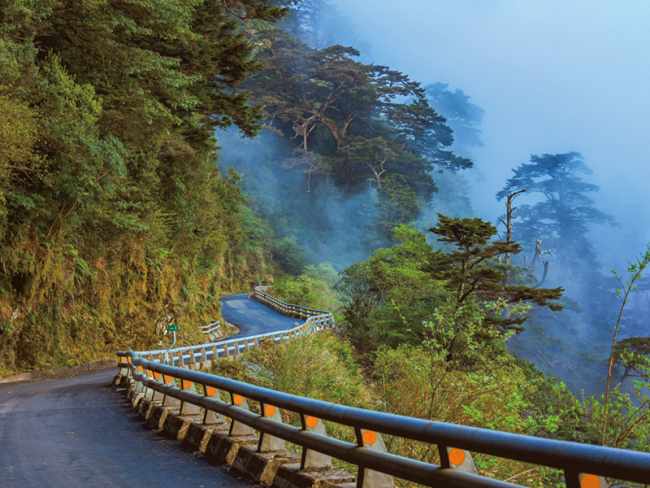
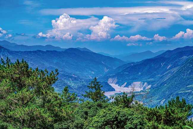
The Southern Cross-Island Highway, also known as the Nanheng Highway, reopened to the public this May following 13 years of repairs. One of three east-west highways constructed across Taiwan's Central Mountain Range, it chisels its way from Tainan City's Yujing District, through Liouguei and Jiasian districts in Kaohsiung, before following the upper reaches of the Laonong River. It ends in Haiduan Township in Taitung County.
The entire road can be driven in a single day, but it is better to arrange a two-day trip to fully experience the breathtaking mountain views along the highway.
|
 |
Lavulang Community's Foreste
Woodlands overseen by the Bunun indigenous people of Lavulang Community are an excellent option for those eager to avoid crowded tourist destinations. The best way to explore Mount Tieben's primary forest is to arrange a tour with Yisihtanda?Anu, a Bunun tribesman who runs a bed-and-breakfast in Taoyuan District. Long ago, Lavulang Community was located in the forest, which is around 1,600m above sea level.
The Isbukun people, a branch of the Bunun tribe, migrated southward from what is now Nantou County more than 200 years ago, settling in a number of locations, including Lavulang. To protect the forest's ecosystem, responsible management of the forest was returned to the community last year.
|
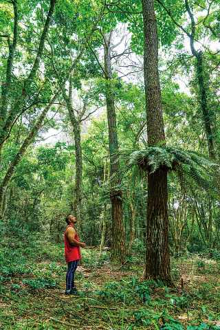  |
Even in midsummer, the forest offers cool temperatures. At the traditional prayer site (known in the Bunun Austronesian language as the Patvisan), native trees and plants — some of them more than 200 years old — thrive. Among them are Taiwan apple trees, maple trees, ring-cupped oaks, beech trees, litsea cubeba (mountain peppercorn, a food flavoring known to Mandarin speakers as magao, and called maqaw in some indigenous languages), and Mucuna macrocarpa.
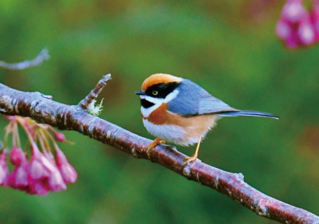
Bird enthusiasts might glimpse the Swinhoe's pheasant or the Taiwan blue magpie. The Reeves's muntjac — a small deer-like creature — is also seen hereabouts.
|
 |
To make it easier for visitors to experience the Lavulang Community's forest culture, Anu's family repaired the ancient path their ancestors once used and created a park in the forest to allow tourists to experience arboreal culture. Visitors can enjoy Bunun-style meals while hearing clan lore at Lavulang Wooden House B&B.
After exploring the forest, visitors with enough time may want to drive to Meishan, one of the Southern Cross-Island Highway's busiest villages. The Bunun Cultural Exhibition Center close to Meishan Visitor Center is certainly worth visiting, a highlight being the replica slate house. Inside the center, visitors can learn about the Bunun people's migrations, as well as the tribe's legends, festivals, and traditional weaving.
|
Jhongjhihguan Old Trail
During the 1895-1945 period of Japanese colonial rule, the Japanese built the 171.06-kilometer-long Guanshanyueling Old Trail to better control the rebellious Bunun population around the Laonong River. The trail, which was completed in 1931, started from Liouguei in the west and ended in what is now Guanshan Township in Taitung County in the east. Today's Southern Cross-Island Highway follows a similar route to Guanshanyueling Old Trail. Among the few preserved segments of the colonial-era trail, the most intact is Jhongjhihguan Old Trail. This 3.6km-long route inside Yushan National Park is between 1,900 and 2,300 meters above sea level.
|
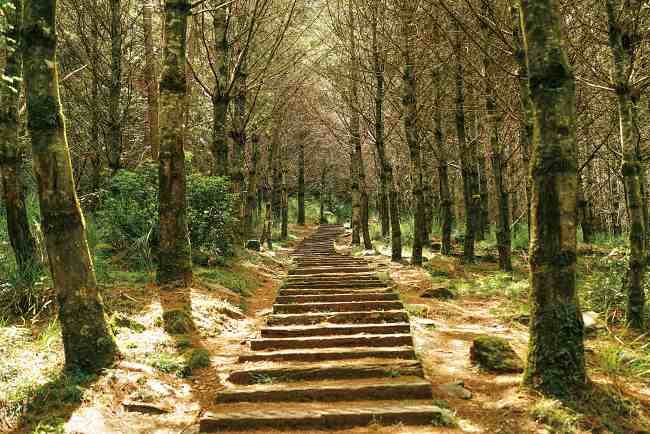 |
| Tourists eager to visit Jhongjhihguan Old Trail are advised to start from the parking lot below Changcing Shrine (which honors the 116 workers who died constructing the Southern Cross-Island Highway) and follow the stairs next to the shrine. From the shrine, there are superb views over the surrounding mountains. It is not difficult to picture how difficult the building of the road must have been.
|
| Walking along the boardwalk behind Changcing Shrine, it does not take long to reach a heart-shaped pond at an altitude of 2,280 meters. Taiwan red pines and spruces grow near the pond. Beyond the pond, the full coniferous forest comes into view. A forest fire some years ago has left behind a breathtaking yet forlorn forest landscape.
|
 |
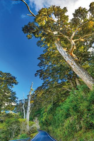
A half-circle around the pond connects you to Jhongjhihguan Old Trail. Along the way, you can see huge towering red cypresses and lush patches of woodland. Along the trail, it is possible to see the remains of charcoal kilns that date from the colonial era. These kilns supplied the nearby police station.
If visitors drive toward Taitung for approximately 5km, they will reach a section of road named Kuaigu (literally “Cypress Valley”). Here, towering cypress trees dwell within the forest fog belt. The afternoon clouds and mists make this a special spot for hikers, motorists, and all kinds of nature lovers.
|
Travel Info:
Meishan Visitor Center (Yushan National Park) 玉山國家公園-梅山遊客中心
Address: No. 44-5, Meishan Ln., Meishan Vil., Taoyuan Dist., Kaohsiung City
Phone: 07-686-6181
|
Nanheng Lavulang Wooden House B&B 南橫.拉芙蘭木屋民宿
Address: No. 90, Sec. 5, Nanheng Highway, Lafulan Vil., 3rd Neighborhood, Taoyuan
District, Kaohsiung City
Phone: 0978-541795
FB: Nanheng Lavulang Wooden House B&B (Chinese only)
|
| |
| TOP |
 |
|